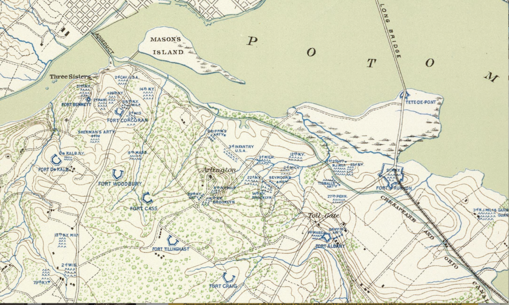
During the first few months of the Civil War, Brigadier General Irvin McDowell ordered a topographical survey of Union forces and defenses in Northern Virginia. The survey led to the creation of a detailed map that shows the locations of forts and regimental camps. Almost 160 years old, the “Map of the Ground Occupation and Defense of the Division of the U.S. Army in Virginia” is a visual reminder of the tens of thousands of Union troops that once occupied Arlington County.
The McDowell survey is part of a broader digital humanities project to use historic maps to plot the location of these forgotten sites on a contemporary and online map. While the location of the forts are well known, the challenge is trying to identify the precise GIS coordinates of the camps. The goal of “Mapping the Civil War in Arlington” is to provide an educational resource for three primary audiences. These include: 1) fourth grade teachers and students in Arlington County, 2) Civil War historians, and 3) local neighborhood associations.
In the state of Virginia, the topic of the Civil War is introduced to elementary students in the 4th grade. “Mapping the Civil War” brings history closer to home for these students. Plotting the locations of Union camps on a modern map using applications like Keppler.gl, will help students to literally discover the history in their backyards. Teachers will be able to use the GIS data to create visual timelines and track how the Union Army grew in size.
For Civil War historians, “Mapping the Civil War” makes accessible a new collection of data that focuses on a relatively unknown historical period. From May to October 1861, Arlington was the front line between Union and Confederate forces. A comprehensive overview of the location of the regimental camps, forts, and military engagements provides a different narrative. These northern regiments, were untested, poorly trained, and experiencing the south for the first time. Many of the Union Army’s future military heroes , like William Tecumseh Sherman, were still not battle tested.
Finally, neighborhood associations in Arlington are very active in historic preservation. “Mapping the Civil War” provides these associations with a new historic perspective. Residents will be able to look online and see who camped in their backyards.
In order to reach teachers, students, historians, and local residents, “Mapping the Civil War” requires a well defined social media strategy. Since the project has a wide audience, it will require the use of several different social media platforms and tools. At the core of the strategy will be the use of a website that will host the online mapping tool. The site will also provide teacher guides and proposed learning activities for students.
The strategy will also include a blog that will provide a location for historians to review update research and engage one an other. The project blog should be updated frequently. In addition, the project should utilize YouTube and Instagram to encourage project contribution by generating “then and now” videos. The goal would be to get students to go visit sites near their elementary school and integrate historic photos with contemporary video.
In regard to the project’s overall message, Civil War history is going through a 21st century revision. As a southern state, Virginia traditionally looked back at the Civil War through a “Lost Cause” filter. But “Mapping the Civil War” provides a new narrative that highlights Arlington’s role in saving the Union, freeing the slaves, and the creation of the Army of the Potomac.
During the first year of the Civil War Arlington was host to tens of thousands of young, inexperienced soldiers from all over the north. These men spent months in Arlington learning how to fight and eventually win the war. Many of the soldiers wrote letters to family back home and kept diaries about their experiences in Arlington and life in the army.
The project networks the digital collections of these first hand accounts with where the soldiers camped. This provides students in Arlington an opportunity to personalize and connect with their local history.
Another goal is to engage with a large group of Civil War historians and researchers. This period of Civil War history has often been overlooked. The project is not only about mapping the physical location of the Union regiments, but tracking their activities later in the war. Enabling and leveraging crowdsourcing will shed light on new historical perspectives.
Finally, utilizing Facebook, the project can engage and assist local neighborhood associations with future preservation projects. For example, as part of the “Lost Cause” legacy, many Arlington street names still favor Confederate generals. It would be interesting if the project could encourage and support the renaming of some of these streets with Union officers like General Sherman.
As part of the social media strategy the project will identify some “SMART” goals. These will include specific, measurable, realistic, and time-bound goals. For example, the success of the Facebook strategy will be determined by how many of the neighborhood association sites promote the project. The website and blog statistics will also provide a benchmark for tracking audience growth and an opportunity to respond to comments and questions. The posting of YouTube and Instagram videos and photographs will provide a significant measurement of how well the project is engaging with the local schools. A final measurement of success will be to track and identify other social as well as traditional media responses to the story.