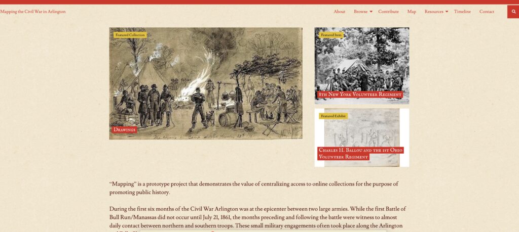
This week’s assignment is to present an argument of our final project and the intellectual and practical justifications for the choices we made in creating it. Also, we have to explain how we plan on evaluating our work. In response to the assignment, the title of my post rather explains it all. Arguing history is a process of discovery. In fact, the root of the word history, comes from the Greek word “historia” which originally meant “inquiry” or the act of seeking knowledge. But in regard to my project “Mapping the Civil War in Arlington” it also means the knowledge that results from inquiry.
From an intellectual and practical justification, the accessibility of digital collections demonstrated by “Mapping” is providing new and public venues for amateur and professional historians to research and analyze history. For years the argument supported by local historians in Arlington was that nothing much happened here during the war. There was some mention of the construction of the 22 forts built to defend the Capital, and the numerous Union camps that dotted the countryside. But not much discussion or interpretation in regard to the early military conflict between these two opposing armies in northern Virginia along the Arlington, and Falls Church border. While the Civil War was well documented only until recently could an individual search and discover large volumes of newspaper accounts, illustrations, photographs, books and diaries. Public access to these digital collections, including historic newspapers and official military documents now reveal more frequent and intense military engagements that often met with deadly consequences. This rediscovery of the past requires a new and refreshed historic interpretation of Arlington’s role during the Civil War.
The Omeka platform that supports my final project, provides a simple and easy to build collection database, along with a contribution feature, that enables Arlington audiences to participate and collaborate in defining and preserving their history. This shared approach, will provide a stronger “historical argument” due to the wisdom offered by a wider source of contribution. The power of inquiry will be magnified and the long hidden or forgotten primary resources can be easily rediscovered.
It is also clear that audiences in the 21st century are definitely influenced by public opinion. Recently there has been a strong response to dated Civil War scholarship. As result public access to digital collections invariably requires or even demands frequent updates to traditional historical arguments. For example, the 20th century acceptance of southern historians and their “Lost Cause” take on the Civil War, has yielded in the 21st century almost as fast as the tumbling of Confederate generals and their statues. For Arlingtonians, “Mapping” provides the next generation of historians, with a better vantage point or knowledge base. Many visitors to “Mapping” have already started to comment that the collection is helping them to recognize that a lot of history actually happened here.
Unfortunately, the recent launch of “Mapping” was too late to contribute to saving the historic Civil War era Febrey house located on Upton’s Hill. However, the public campaign to save it was a motivating factor in creating the site. With the demise of the Febrey house, what then will be the evaluation criteria to measure “Mapping’s” success?
Evaluation Criteria #1
April 12th, 2021 is the 160th anniversary of the start of the Civil War. As a result, there is going to be a renewed interest in the Civil War and local history in Arlington. An important evaluation criteria will be the number of unique visitors.
The project is designed for several key personas. These include local historians, teachers, students, and history buffs. The primary audience will be on local historians. The secondary audience will be for teachers. In regard to local historians, the site is intended to become an important source of validating historical authenticity and presenting new discoveries. It will provide a venue for sharing knowledge and collection sources. For teachers, the site will include lesson plans and activities targeted for Arlington students. These activities will promote local history and discovery of important Civil War sites, including Upton’s Hill.
Evaluation Criteria #2
The project will attract a lot of attention from Civil War historical societies and roundtables. Engagement with these groups will increase collection contributions. Stories about Arlington and the war may be new to many in this audience. However, since during the Civil War regiments from over 15 states camped in the county, there may be a greater national interest. One benefit of seeking a wider audience is the potential for new and undiscovered primary sources. These history buffs could be the “wisdom of the crowd” and their engagement could fill in some missing historical references and add to new interpretations.
Evaluation Criteria #3
Finally, an important and critical criteria is collecting audience feedback. The “contact us” feature will be used to gather usability assessments and help determine what platform features or corrections need to be made. Also, since the site is still in development, users can help identify basic typos or ther human errors that should be easily corrected.
Final Thoughts on Arguing History
Mapping the Civil War in Arlington was originally intended to be a resource to support historic preservation. However, the argument to save history goes beyond a physical building or property. So in the case of the Febrey house, the primary argument is not whether a owner has the right to sell their land, but rather who owns the history associated with a property. Hence, the argument that all history is public supports the necessity to efficiently capture and curate historical knowledge. The demolition of the Febrey house without any curation or discovery is painful. Like the burning of books, the knowledge is gone and unrecoverable. But hopefully its demise will serve as a reminder to the people living in Arlington that saving history is a collaborative and shared process. Projects like “Mapping” will continue to make the argument that inquiry and knowledge go hand in hand. You can’t have one without the other.